


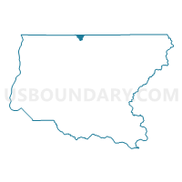
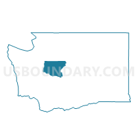
Bacus Voting District, King County, Washington
About
Outline

Summary
| Unique Area Identifier | 685652 |
| Name | Bacus Voting District |
| County | King County |
| State | Washington |
| Area (square miles) | 4.26 |
| Land Area (square miles) | 4.17 |
| Water Area (square miles) | 0.09 |
| % of Land Area | 97.94 |
| % of Water Area | 2.06 |
| Latitude of the Internal Point | 47.76208670 |
| Longtitude of the Internal Point | -121.90486370 |
Maps

Graphs
Select a template below for downloading or customizing gragh for Bacus Voting District, King County, Washington


Neighbors
Neighoring Voting District (by Name) Neighboring Voting District on the Map
- Cherry Valley Voting District, King County, WA
- High Rock Voting District, Snohomish County, WA
- Lake Joy Voting District, King County, WA
- Stillwater Voting District, King County, WA
- Tualco Voting District, Snohomish County, WA
Top 10 Neighboring County Subdivision (by Population) Neighboring County Subdivision on the Map
Top 10 Neighboring Unified School District (by Population) Neighboring Unified School District on the Map
Top 10 Neighboring State Legislative District Lower Chamber (by Population) Neighboring State Legislative District Lower Chamber on the Map
Top 10 Neighboring State Legislative District Upper Chamber (by Population) Neighboring State Legislative District Upper Chamber on the Map
Top 10 Neighboring 111th Congressional District (by Population) Neighboring 111th Congressional District on the Map
Top 10 Neighboring Census Tract (by Population) Neighboring Census Tract on the Map
- Census Tract 324.01, King County, WA (5,859)
- Census Tract 325, King County, WA (5,237)
- Census Tract 538.01, Snohomish County, WA (3,639)